Curriculum
The Mobile Robotics Program is extend over 24 months and is structured into mandatory and elective modules, including teaching units with a duration of one semester. Each module is completed with an exam. Three different types of modules are offered: lectures, seminars, and projects. The basis of evaluation is credit points (CP).
The Master's Program consists of four types of courses:
6 General Mandatory Modules, which cover the basic knowledge required for the remaining program.
6 Elective Modules, which provide a broad overview of the subject area.
2 Project Modules, which introduce to current research topich and train for self-sufficent research.
1 Master Thesis, as written final exam paper.
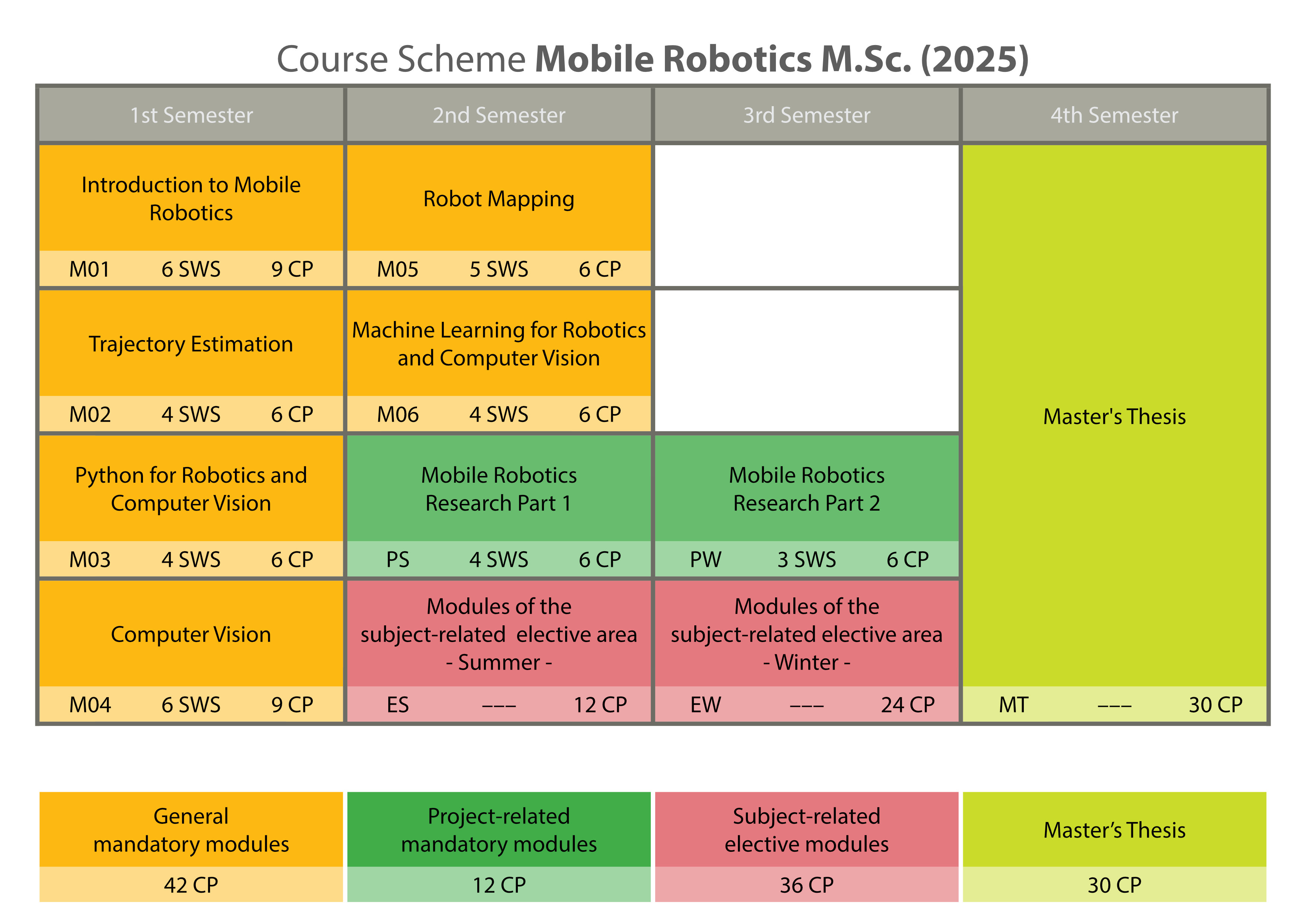
General Mandatory [ 42 CP ]
The modules cover the basic knowledge required for the remaining program. Lectures and exercises cover the folowing topics: Robot Planning and Control, GNSS, Inertial Navigation Systems, Python and Computer Vision, Graph SLAM, 3D Mapping and Maschine Learning.
- Introduction to Mobile Robotics (MA-MOROB-M01 | 9 CP)
- Trajectory Estimation (MA-MOROB-M02 | 6 CP)
- Python for Robotics and Computer Vision (MA-MOROB-M03 | 6 CP)
- Computer Vision (MA-MOROB-M04 | 9 CP)
- Robot Mapping (MA-MOROB-M05 | 6 CP)
- Machine Learning for Robotics and Computer Vision (MA-MOROB-M06 | 6 CP)
Project Modules [ 12 CP ]
The Project modules extend over two semesters. They cover current research topics
- Topics
- Moving objects; Pose estimation and localization; Trajectory estimation; Simultaneous localization and mapping; Sensor calibration; Sensor fusion; Advanced sensor data interpretation; Pointcloud processing; Machine learning for perception; Semantic sensor data interpretation; AI techniques for robot navigation
Elective Modules [ 36 CP ]
In the second and third semester the students choose elective modules from the fields of Geodesy and Computer Science. This gives the students a broad overview about the subject.
It is also possible to choose a course from the university-wide offer with 6 credit points.
Master's Thesis [ 30 CP ]
The Master's Program concludes with the Master's Thesis, in which a geodetic problem as to be solved.
Qualification Goals: Independent and extensive analysis and interpretation of a research task; Ability to independently cope with a scientific problem in the relevant subject area on the basis of scientific methods within a set period of time; Specialized professional and conceptual skills to assess and present the research results; Systematic search of information and literature; Understanding and using scientific texts; Writing scientific text in a concise way; Presentation of findings and results.